Earthwork Quantities

The most flexible takeoff solution Designed with you in mind

How it Works

No time to learn? No problem. Call us and we'll walk you through it all.

More InfoGet a walkthrough | Get a trial

Cut Fill Shading Map

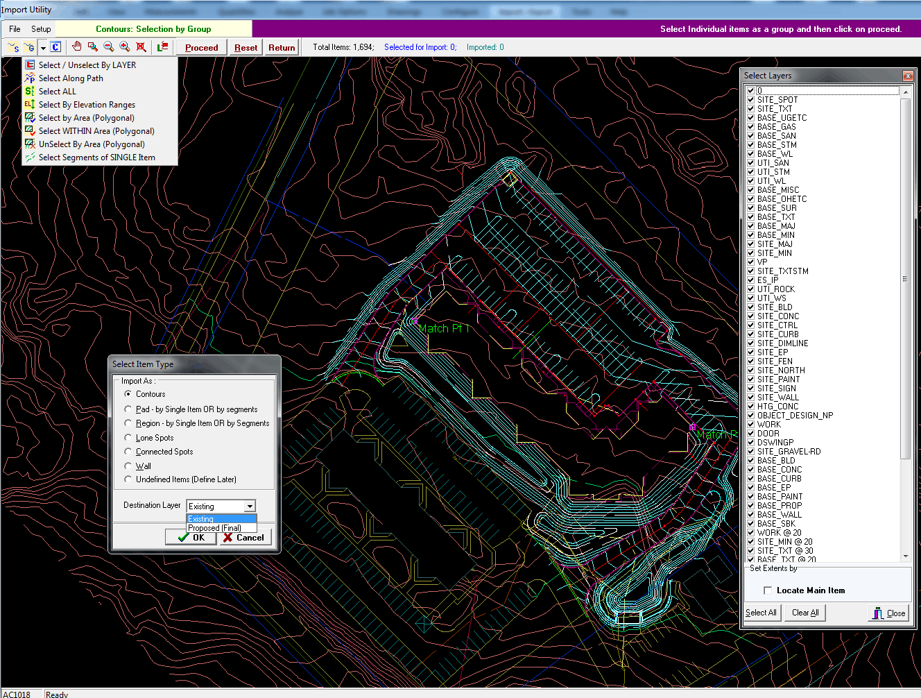
Simply load your drawing and get started on your takeoff. Import linework from vector PDF or CAD. Add material areas, trenches, walls, curbing, strata, or any other aspect as needed. We handle it all.

Site balancing and intuitive editing allow you to easily play the "what-if" game and maximize value engineering. Don't just get accurate quantities from the engineer's design; create a realistic site that will save money and be able to prove your work.

No problem! Simply use alternate plan to move your takeoff to as many detail sheets as needed to get the whole picture in one consolidated takeoff with one report. Our software will even remember your page setup for future use so you can revisit an alternate page anytime with ease.

Don't be afraid to make a mistake. Our advanced and flexible editing options will have you covered from minor reshaping to completely replacing an area.

Let change orders become a breeze. Save multiple versions of your site and compare quantities without starting your takeoff over from scratch. 

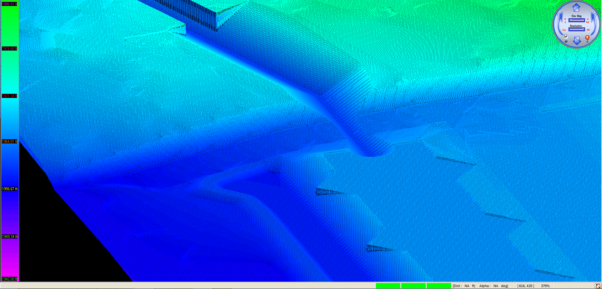
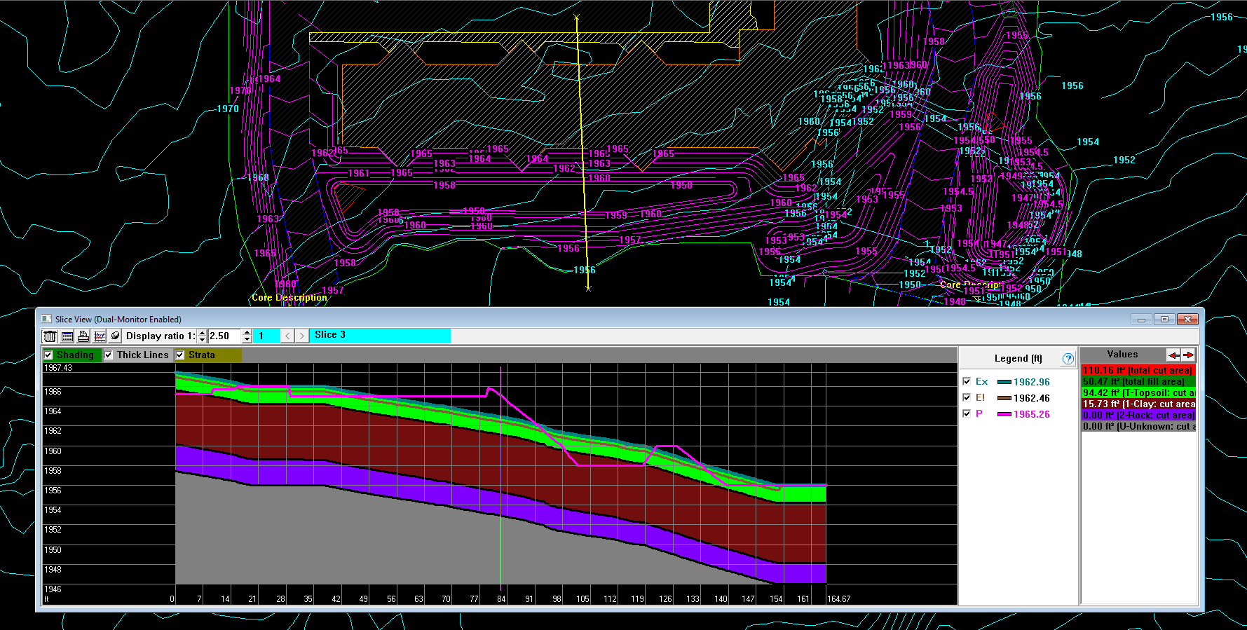
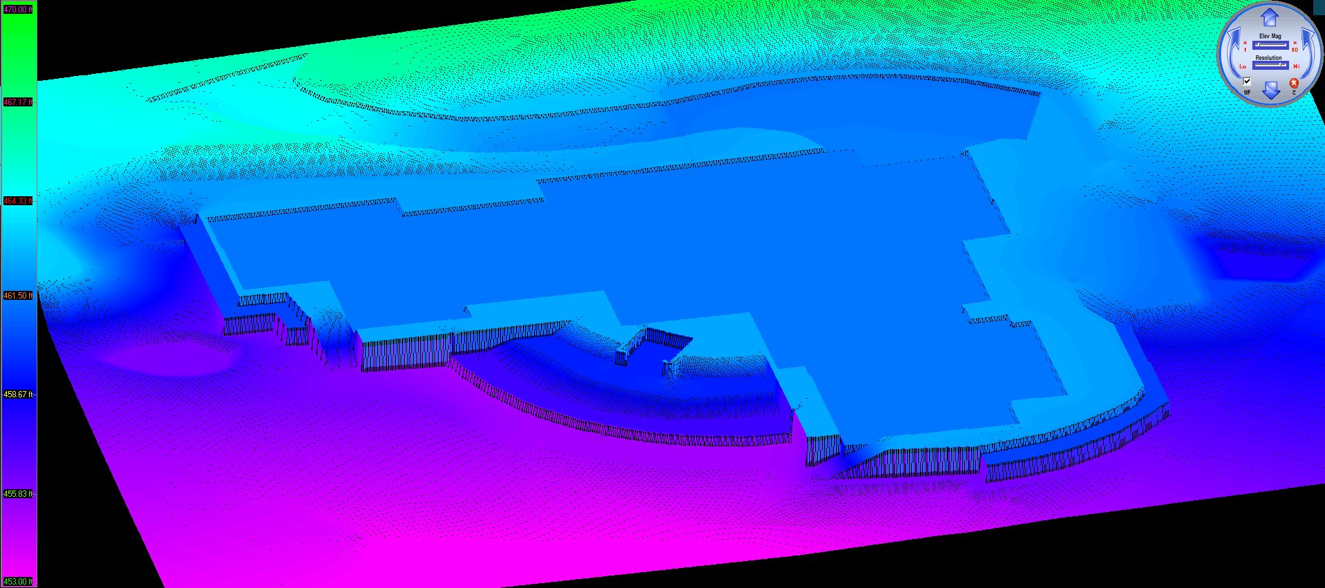
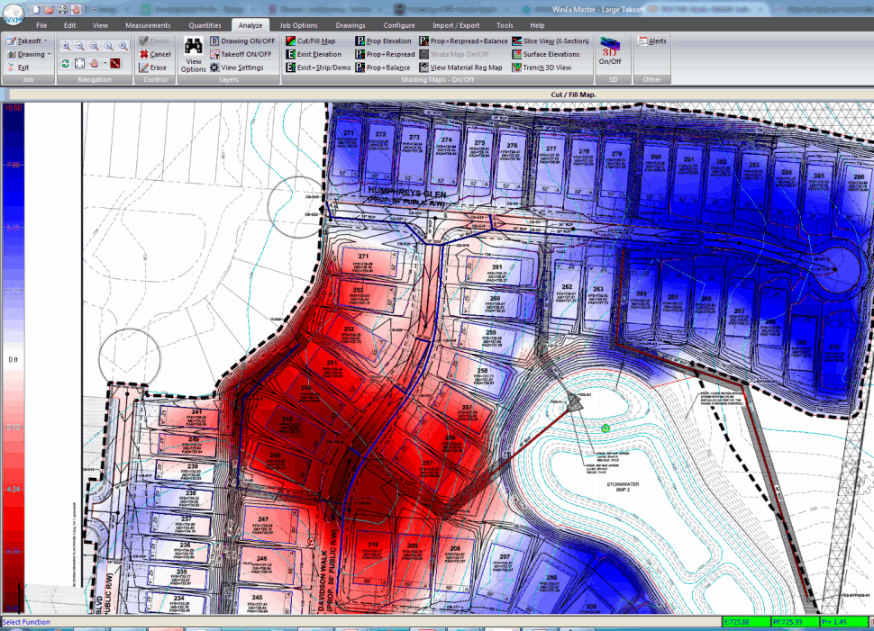
Use our analysis tools like the cut/fill map, existing/proposed elevation maps, slice view, and 3D to double check your site and ensure accuracy. Use our visualization tool to show a fluidly rotating 3D view of your site and watch it change in real time as you make adjustments to your takeoff.

Print your reports, export to any spreadsheet, or one click transfer to Excel. You can even export your takeoff to CAD/GPS. Get formal reports, analyze cross section slices, examine cut/fill maps to plan your sitework, and create amazing 3D images to show your clients. 

Earthwork

Whether you're a GC, subcontractor, or complete all sitework yourself, our WinEx line has the civil solution for you. Quantities can make or break a bid, but it shouldn't take days to get a guesstimate. Step up your game and get faster quantities you can trust with Roctek's precision excavation takeoff software.

View Gallery
Features comparison
Start your trial

Cut Fill Takeoff Software

WinEx Grade

Tackle your takeoff with WinEx Grade. Handle all standard measurements (2D takeoff), material quantities, site balancing, multiple sheets, importing, shrink/swell, strip/respread, custom formulas, walls, trenches, over-ex, footings, utilities, and so much more! Get quantities in either imperial or metric. Isolate any aspect of your takeoff to organize your quantities on formal reports. See your site in 3D and create images your clients will love!

Earthwork Takeoff Software

WinEx Master

You get all the features of WinEx Grade plus additional advanced tools to make your job even easier. See plan/profile trenches in 3D, export your linework to Land XML (GPS) or CAD (DXF), use advanced editing options such as copy/paste pads, create horizontal or vertical offsets, partial perimeter over-ex, follow your takeoff through time with multi-phase, create a total site plan from matchlines with Planbuilder, and more!

Which Product is Right for You

This is a brief overview of the differences between WinEx Grade and WinEx Master. Not all features of either product are listed. Feel free to ask us if you're looking for a feature not listed below.

Features WinEx Grade WinEx Master
Precise cut/fill volumes for 2D and 3D takeoffs
Advanced tracing tools to draw faster and re-use your own linework
Subsurface Strata (Bore Logs & Core Samples)
Trenching and Utilities
Import Linework from Vector PDF or CAD
Handles Multiple Sheets in One Takeoff
Cross Sections, Elevation Shading, Cut/Fill Shading Analysis
View All Shading Maps in 3D
Imperial or Metric Scaling
3D site visualization that updates in real time
Quickly Over-Excavate around Pad Perimeters
Create Vertical and Horizontal Offsets
Handle Grading Changes Through Time with Multi-Phase
Advanced Editing such as Copy/Paste
3D Plan and Profile View Trenching
Create a Total Site Plan with Planbuilder
Export Your Linework to LandXML or CAD
Export to GPS machine control

Let's Get Started

We love our software, but why take our word for it?
Take it for a test drive today and start bidding with confidence. Let us show you how you can save time and money with on-screen training.